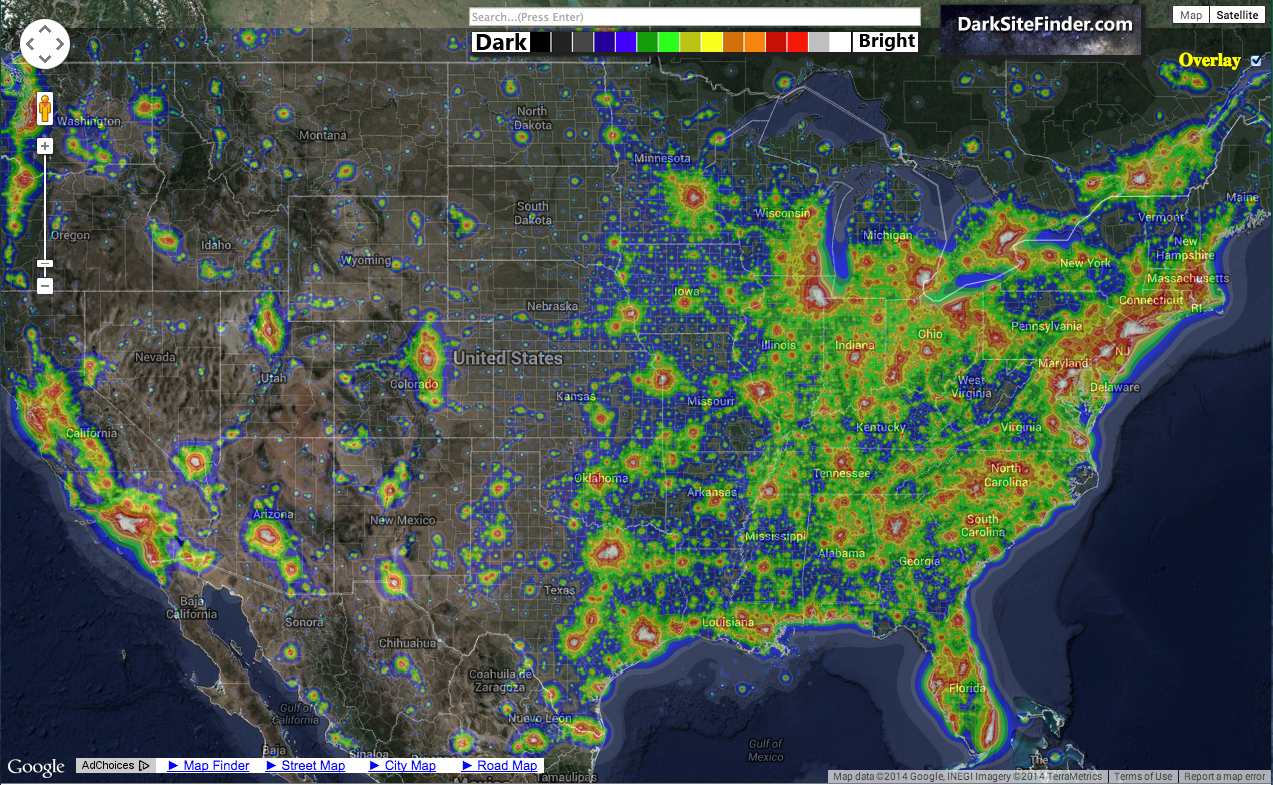
Recently some article about an upcoming astronomical event, I don’t recall which one, referred to the web site darksitefinder.com and the typical light pollution maps there. The maps illustrate the light being emitted from the earth, mostly man-made, light that is strongly reflected back from the atmosphere that illuminates the night sky, obscuring the view of distant, astronomical objects. But I noticed something that hadn’t caught my eye before.
There was a very distinct line separating densely populated areas from the eastern continental United States from the west. Sure, I know the West is more sparsely populated, at least until you get to the West Coast, but I didn’t know the dividing line dropped off so sharply. The illumination levels correlate pretty well with population so this is population density we’re seeing here in nearly all cases.
The drop off edge doesn’t quite match anything I can think of. It’s not aligned with the Mississippi or any river really, or other geologic feature, or a shift in climate or moisture. There are cases of all of those near the line but they don’t quite match. Some don’t match by a long shot. I wondered if it might be a major north-south railway that the last wall of cities there lies along. That might be but then you’d still have to ask why the railroad ran along that line.
There’s no historical boundary that corresponds either, that I’ve been able to find so far.
There must be something going on here. Some global characteristic of the continental U.S. that’s larger than the growth and development of little independent population centers. A sharp line like that doesn’t imply independence. (To be clear, I mean in the mathematical, process sense).
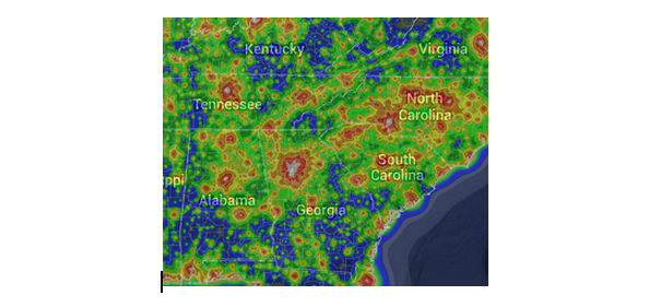
I’m also fascinated by the rectangle of cities that Atlanta lies in. The shape of Atlanta’s light blob reveals the three fingers of growth to the north along the I-75, Georgia 400, and I-85 corridors.
The bottom side of the rectangle is Montgomery, Columbus, Macon, and Augusta. The top side is Huntsville, Chattanooga, and Asheville. Huntsville, Birmingham, and Montgomery make the west edge. Asheville, Greenville-Spartanburg, and Augusta make the east edge.
Knoxville is almost part of the northern edge but is stretched up north, because it follows I-75 I think.
The population flow from Atlanta to Greenville-Spartanburg, Charlotte, Greensboro, and Raleigh-Durham is fairly prominent.
You can also see the dark skies (the blue area) of Eastern Georgia between Atlanta and Augusta. That’s the location both of Georgia State’s Hard Labor Creek observatory and the Deer Lick Astronomy Village. In sad contrast, notice how little dark sky is left in the North Georgia Mountains north of Atlanta.